Wielkopolska Digital Library contains 449 941 digital objects
Object
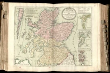
Title: Le Royavme d'Escosse divise en deux Parties, Subdivisees en Provinces etc. Dresse
Contributor:
Coronelli, Vincenzo (1650–1718)
Publisher:
Place of publication:
Description:
Mapa w atlasie sztucznym, T.1 ; 1 ark. miedz. kolor. powierzchniowo 46x60,7 cm na ark. 52,3x69,9 cm ; Tyt. w kartuszu. ; Mapa pochodzi z atlasu N. Sansona: "Cartes Generales de toutes les Parties du monde". ; Rzeźba terenu przedstawiona metodą kopczykową. ; Podziałki liniowe w kartuszu. ; [Mapki dodatkowe:] Les Isles de Ferro ou Farre. Les Isles de Schetland. Les Isles d'Orkney ou Orcades.
Language:
Rights Management:
Rights:
Access rights:
Digitisation:
Digitisation sponsor:
Location of original object:
Digital object format:
Signature:
Object collections:
- Digital Library of Wielkopolska > Digital Library of Wielkopolska
- Digital Library of Wielkopolska > Digital Library of Wielkopolska > Cultural heritage
- Digital Library of Wielkopolska > Instytucje współtworzące > Biblioteka Kórnicka PAN
Last modified:
Oct 10, 2019
In our library since:
Oct 10, 2019
Number of object content hits:
12
Number of object content views in DjVu format
25
All available object's versions:
https://wbc.poznan.pl/publication/564222
Show description in RDF format:
Show description in OAI-PMH format:
| Edition name | Date |
|---|---|
| Le Royavme d'Escosse divise en deux Parties, Subdivisees en Provinces etc. Dresse | Oct 10, 2019 |
Objects Similar
Sanson d'Abbeville, Nicolas (1600–1667)
Simonneau, Carles Louis (1645-1728) graw. kartusza Liebaux, Jean Baptiste (1679-1725) graw. Delisle, Guillaume (1675–1726)
Coronelli, Vincenzo Maria (1650–1718) Tralage, Jean-Nicolas de (1640?-1720) Guerard, Nicolas (1648?-1719)
Sanson d'Abbeville, Nicolas (1600–1667)
Sanson d'Abbeville, Nicolas (1600–1667)
Sanson d'Abbeville, Nicolas (1600–1667)
Sanson d'Abbeville, Nicolas (1600–1667)

