Wielkopolska Digital Library contains 450 543 digital objects
Object
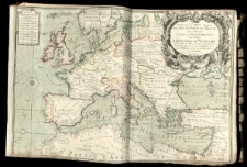
Title: Nouvelle Carte marine de tout les Ports de l'Europe sur l'Ocean et sur la Mediterranee.
Contributor:
Berey, Claude-Auguste (1651–1732)
Publisher:
Place of publication:
Description:
Mapa w atlasie sztucznym, T.1 ; 1 ark. miedz. kolor. liniowo i powierzchniowo 52,6x79,6 cm ; Południk zerowy Ferro. ; Tyt. w kartuszu z herbem Louisa Phelypeauxa Pontchartraina, okrętem oraz dewizą: "Fausta omnia dum regunt". ; Arkusz przycięty na linii górnej i dolnej ramki mapy; odcięty adres wydawniczy.
Language:
Rights Management:
Rights:
Access rights:
Digitisation:
Digitisation sponsor:
Location of original object:
Digital object format:
Signature:
Object collections:
- Digital Library of Wielkopolska > Digital Library of Wielkopolska
- Digital Library of Wielkopolska > Digital Library of Wielkopolska > Cultural heritage
- Digital Library of Wielkopolska > Instytucje współtworzące > Biblioteka Kórnicka PAN
Last modified:
Oct 10, 2019
In our library since:
Oct 10, 2019
Number of object content hits:
58
Number of object content views in DjVu format
41
All available object's versions:
https://wbc.poznan.pl/publication/564144
Show description in RDF format:
Show description in OAI-PMH format:
| Edition name | Date |
|---|---|
| Nouvelle Carte marine de tout les Ports de l'Europe sur l'Ocean et sur la Mediterranee. | Oct 10, 2019 |
Objects Similar
Delisle, Guillaume (1675–1726)
Ancillon, Johann Peter Friedrich (1767–1837)
Lansius, Thomas
Wiitsius, Egidius
Hondius, Henricus (1597–1651) Ianssonius, Ioannes Monatus, Petrus (1560–1625) Visscher, Nicolaes (1649–1702) Braun, Georg (1540–1590) Hogenberg, Franz (1541–1622) Witt, Frederick de (1630–1706) Hogeboom, Andries (kartograf ; rytownik 1680-1701)
Pacichelli, Giovanni Battista
Pacichelli, Giovanni Battista

