Wielkopolska Digital Library contains 449 941 digital objects
Object
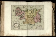
Title: Tabula Islandiae auctore
Contributor:
Blaeu, Willem Janszoon (1571–1638) ; Blaeu, Joan (1596–1673)
Publisher:
Place of publication:
Description:
Mapa w atlasie sztucznym, T.1 ; Mapę ogranicza ramka z podziałem minutowym, oznaczona co 6' i opisana co 1°. ; Na mapie siatka geograficzna, dwie róże wiatrów, linie rumbowe oraz erupcja wulkanu Hekla. ; Tyt. w kartuszu. ; Mapa najprawdopodobniej pochodzi z "Atlas Maior" Joana Blaeua. ; Podziałki liniowe w kartuszu. ; Mapa z podziałem administracyjnym.
Language:
Rights Management:
Rights:
Access rights:
Digitisation:
Digitisation sponsor:
Location of original object:
Digital object format:
Signature:
Object collections:
- Digital Library of Wielkopolska > Digital Library of Wielkopolska
- Digital Library of Wielkopolska > Digital Library of Wielkopolska > Cultural heritage
- Digital Library of Wielkopolska > Instytucje współtworzące > Biblioteka Kórnicka PAN
Last modified:
Oct 10, 2019
In our library since:
Oct 10, 2019
Number of object content hits:
31
Number of object content views in DjVu format
36
All available object's versions:
https://wbc.poznan.pl/publication/564136
Show description in RDF format:
Show description in OAI-PMH format:
| Edition name | Date |
|---|---|
| Tabula Islandiae auctore | Oct 10, 2019 |

