Wielkopolska Digital Library contains 421 713 digital objects
Object
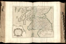
Title: L'Escosse deça le Tay, divisee en ses Provinces &c. tirees de toutes les Cartes particulieres qu'en ont faict Timothee Pont, Robert Gordon a Straloch, &c.
Contributor:
Sanson d'Abbeville, Nicolas (1600-1667)
Description:
Mapa w atlasie sztucznym, T.1 ; 1 ark. miedz. kolor. powierzchniowo 40,4x54,8 cm na ark. 52,5x71,9 cm ; Rzeźba terenu przedstawiona metodą kopczykową. ; Tyt. w kartuszu. ; Mapa pokazuje granicę między Szkocją a Anglią. ; Mapę ogranicza ramka stopniowa, oznaczona i opisana co 10" ; Mapa pochodzi z atlasu N. Sansona: "Cartes Generales de toutes les Parties du monde". ; Autorami opracowania byli: Timothy Pont i Robert Gordon. ; Podziałki liniowe na mapie.
Publisher:
Place of publication:
Signature:
Language:
Rights Management:
Rights:
Access rights:
Digitisation:
Digitisation sponsor:
Location of original object:
Digital object format:
Object collections:
- Digital Library of Wielkopolska > Digital Library of Wielkopolska
- Digital Library of Wielkopolska > Digital Library of Wielkopolska > Cultural heritage
- Digital Library of Wielkopolska > Instytucje współtworzące > Biblioteka Kórnicka PAN
Last modified:
Oct 10, 2019
In our library since:
Oct 10, 2019
Number of object content hits:
11
Number of object content views in DjVu format
7
All available object's versions:
https://wbc.poznan.pl/publication/564134
Show description in RDF format:
Show description in OAI-PMH format:
Objects Similar
Gordon, Robert (1580-1661) Sanson d'Abbeville, Guillaume (1633-1703) Sanson d'Abbeville, Nicolas (1600-1667) Pont, Timothy (1560-1614)
Sanson d'Abbeville, Nicolas (1600-1667)
Snell, Willebrord (1580-1626) Brahe, Tyho (1546-1601) L'Isle, Guillaume de (1675-1726) Kepler, Johannes (1571-1630)
Delisle, Guillaume (1675-1726)
Delisle, Guillaume (1675-1726) Liebaux (fils) ryt.

