Wielkopolska Digital Library contains 458 088 digital objects
Object
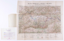
Title: Mapa turystyczna Podhala, Spisza i Orawy
Contributor:
Zwoliński, Tadeusz (1893–1955)
Publisher:
Komitet Nar. Obrony Podhala, Spisza i Orawy
Place of publication:
Description:
Czechy 1920 mapa granic z Polską ; 1:200 000 ; 65,5x43 cm; złoż. w okł. 12,5x21 cm ; 1 ark. ; Na mapie zaznaczone różne projekty granicy polsko-czechosłowackiej ręcznie. Do mapy dołączona kartka z objaśnieniami dotyczącymi projektów
Language:
Digitisation sponsor:
Signature:
Rights Management:
Rights:
Access rights:
Digitisation:
Location of original object:
Object collections:
- Digital Library of Wielkopolska > Digital Library of Wielkopolska
- Digital Library of Wielkopolska > Digital Library of Wielkopolska > Cultural heritage
- Digital Library of Wielkopolska > Instytucje współtworzące > Biblioteka Kórnicka PAN
Last modified:
Oct 30, 2019
In our library since:
Oct 30, 2019
Number of object content hits:
296
Number of object content views in DjVu format
269
All available object's versions:
https://wbc.poznan.pl/publication/538740
Show description in RDF format:
Show description in OAI-PMH format:
| Edition name | Date |
|---|---|
| Mapa turystyczna Podhala, Spisza i Orawy | Oct 30, 2019 |
Objects Similar
Danysz-Fleszarowa Regina. Red.
Patkowski Aleksander. Red.
Walker, John (1787–1873)
Maliszewski Edward. Red.

