Wielkopolska Digital Library contains 448 736 digital objects
Object
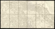
Title: Mappa specialis continens limites inter Regna Poloniiae et Prussiae a Marchia Nova usque ad Vistulam.
Contributor:
Pfau, Theodor Philip von (1727–1794)
Place of publication:
Description:
1:170 000 ; 78x39 cm; złoż. w futerale 20x14 cm ; Rzeźba terenu: metoda perspektywiczna ; Jest to suplement do mapy T. Ph. Pfaua z 1772 r. ; Mapa przedstawia granice Prus z Polską z 1787 r. ; E. XXII , 136
Language:
Signature:
Rights Management:
Rights:
Access rights:
Digitisation:
Digitisation sponsor:
Location of original object:
Digital object format:
Object collections:
- Digital Library of Wielkopolska > Digital Library of Wielkopolska
- Digital Library of Wielkopolska > Digital Library of Wielkopolska > Cultural heritage
- Digital Library of Wielkopolska > Instytucje współtworzące > Biblioteka Kórnicka PAN
Last modified:
Oct 14, 2019
In our library since:
Oct 14, 2019
Number of object content hits:
514
Number of object content views in DjVu format
364
All available object's versions:
https://wbc.poznan.pl/publication/537824
Show description in RDF format:
Show description in OAI-PMH format:
| Edition name | Date |
|---|---|
| Mappa specialis continens limites inter Regna Poloniiae et Prussiae a Marchia Nova usque ad Vistulam. | Oct 14, 2019 |
Objects Similar
Krzepela Józef
Kutrzeba Stanisław (1876–1946)
Endersch, Johann Friedrich (1705–1769) Schraembl, Franz Anton (1751–1803)
Sommer Hugo
Karol VI Habsburg (1685-1740) cesarz Świętego Imperium Rzymskiego od 1711

