Wielkopolska Digital Library contains 421 181 digital objects
Object
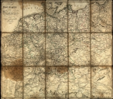
Title: Neuste Post Karte von Deutschland und dessen angrenzenden Laender
Publication date:
Description:
[ca 1:2 500 000] ; 1 ark. miedz. granice kolor. 64x55,5 cm; ark. 65,5x57,5 cm; złoż. 19x13 cm ; Podkl. na płótnie. ; Mapa silnie zniszczona. ; Brak siatki kartograficznej.
Publisher:
Place of publication:
Signature:
Language:
Rights:
Access rights:
Digitisation:
Location of original object:
Object collections:
- Digital Library of Wielkopolska > Digital Library of Wielkopolska > Cultural heritage
- Digital Library of Wielkopolska > Instytucje współtworzące > Biblioteka Kórnicka PAN
Last modified:
Apr 6, 2022
In our library since:
Apr 6, 2022
Number of object content hits:
16
All available object's versions:
https://wbc.poznan.pl/publication/601453
Show description in RDF format:
Show description in OAI-PMH format:
| Edition name | Date |
|---|---|
| Neuste Post Karte von Deutschland und dessen angrenzenden Laender | Apr 6, 2022 |
Objects Similar
Ravenstein, August (geograf ; 1809-1881)
Handtke, Friedrich (1815-1879) Flemming, Carl (1806-1878)
Kahle, Carl Moriz
Hinrichs, Hermann Friedrich Wilhelm (1794–1861)

