Wielkopolska Digital Library contains 449 941 digital objects
Object
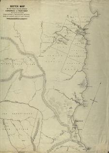
Title: Sketch map of the coast country between Cardwell and Cooktown shewing the lands on the Johnstone and Mulgrave rivers which are specially suied for sugar cultivation
Publisher:
Place of publication:
Description:
Language:
Rights:
Access rights:
Digitisation:
Location of original object:
Signature:
Object collections:
- Digital Library of Wielkopolska > Digital Library of Wielkopolska > Cultural heritage
- Digital Library of Wielkopolska > Instytucje współtworzące > Biblioteka Kórnicka PAN
Last modified:
Apr 8, 2022
In our library since:
Feb 24, 2022
Number of object content hits:
17
All available object's versions:
https://wbc.poznan.pl/publication/598682
Show description in RDF format:
Show description in OAI-PMH format:
Objects Similar
Everett, Arthur Slight, William
1869
mapa
Clarke, William Branwhite (1798–1878)
1878
monografie
Ulrich, George Henry Frederick (1830–1900)
[ok. 1874]
raporty
Lawson, R. H. Bailey, T. S.
1870-1877
mapa
×

