Wielkopolska Digital Library contains 416 854 digital objects
Object
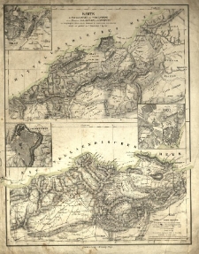
Title: Karte der Provinzen Oran und Constantine mit den Plänen der Städte Oran, Bona und Constantine und eingetragenen Höhen, nach den Aufnahmen des französischen Generalstabes / entworfen und gezeichnet von A. Theinert
Contributor:
Description:
1 ark.: litogr.; 42x32,5 cm. ; [ca 1:823 000] ; Rzeźba terenu oddana metodą kreskowania i punktów wysokościowych. ; Południk 0: Paryż.
Publisher:
Place of publication:
Signature:
Language:
Rights:
Access rights:
Digitisation:
Location of original object:
Object collections:
- Digital Library of Wielkopolska > Digital Library of Wielkopolska > Cultural heritage
- Digital Library of Wielkopolska > Instytucje współtworzące > Biblioteka Kórnicka PAN
Last modified:
Feb 24, 2022
In our library since:
Feb 24, 2022
Number of object content hits:
10
All available object's versions:
https://wbc.poznan.pl/publication/598666
Show description in RDF format:
Show description in OAI-PMH format:
Objects Similar
×

