Wielkopolska Digital Library contains 421 181 digital objects
Object
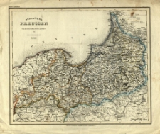
Title: Ost- und West-Preussen. Nach den besten Quellen entworf. und geziechnet vom Radefeld
Contributor:
Description:
10 mil geogr. = 5,5 cm ; 1 ark. ; 41x34,8 cm ; druk ręcznie kolor. ; Mapa należy do: Meyers-Handatlas, (Supplm. 15) N° 115
Publisher:
Place of publication:
Signature:
Language:
Rights Management:
Rights:
Access rights:
Digitisation:
Location of original object:
Digital object format:
Object collections:
- Digital Library of Wielkopolska > Digital Library of Wielkopolska > Cultural heritage
- Digital Library of Wielkopolska > Instytucje współtworzące > Biblioteka Kórnicka PAN
Last modified:
Jan 4, 2022
In our library since:
Mar 1, 2006
Number of object content hits:
372
All available object's versions:
https://wbc.poznan.pl/publication/15105
Show description in RDF format:
Show description in OAI-PMH format:
| Edition name | Date |
|---|---|
| Ost- und West-Preussen. Nach den besten Quellen entworf. und geziechnet vom Radefeld | Jan 4, 2022 |
Objects Similar
1897
czasopisma
1897
czasopisma
Schmalz E. A. W.
1828
ustawy broszury
×

