Wielkopolska Digital Library contains 450 283 digital objects
Object
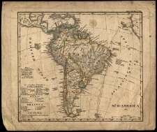
Title: Ameryka Południowa - mapa polityczna
Publisher:
Description:
Nr inw. 0599 ; 22x19,5 cm ; 1:46 300 000 ca ; Stieler's Schul-Atlás nr 20
Language:
Rights Management:
Rights:
Access rights:
Digitisation:
Location of original object:
Digital object format:
Signature:
Object collections:
- Digital Library of Wielkopolska > Digital Library of Wielkopolska > Cultural heritage
- Digital Library of Wielkopolska > Instytucje współtworzące > Biblioteka Kórnicka PAN
Last modified:
Nov 10, 2021
In our library since:
Feb 3, 2006
Number of object content hits:
194
All available object's versions:
https://wbc.poznan.pl/publication/13066
Show description in RDF format:
Show description in OAI-PMH format:
| Edition name | Date |
|---|---|
| Ameryka Południowa - mapa polityczna | Nov 10, 2021 |
Objects Similar
Bastian, Adolf (1826–1905)
1889
monografie
Tuczyński, Franciszek Ksawery (1844–1890)
1882
wspomnienia
×

